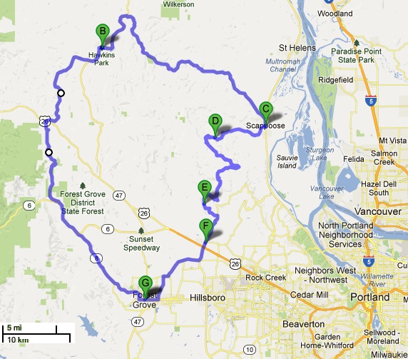
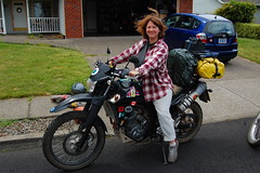

Forest Grove to Vernonia to Scappoose
to North Plains & back to Forest Grove (Oregon)
96 miles, including 16 miles of gravel
|
|

You will come to Scappoose. Turn right onto U.S. 30 E for just 0.6 miles, and then take the first right onto SW Em Watts Rd. It is EASY to miss this road, so... don't!
You will be on this for about 10 miles, and then you will continue onto Dutch Canyon Rd and stay on it for about 3.6 miles.
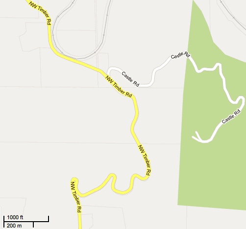
Otto Miller Rd is on left just before Dead End sign on Dutch Canyon Rd. The bridge here is a good place to get a drink of water and contemplate the 16 miles of gravel that starts just a few meters away.
ABOUT THE GRAVEL ROADThe first part of the road is hardest - uphill gravel twisties for about a mile. It's worse if you are coming the other way, since these are downhill. This is a public road, and there may be cars and other motorcyclists out, so on blind curves, take extra care.
Keep following the road for 16 miles. It will become Dixie Rd/Dixie Mountain Rd, but you may never see a sign that says such.
As long as fresh gravel hasn't been laid down, this is a relatively easy gravel road.
There is a point after about 9 miles where you will see a paved road going left. You can take that if you've had enough gravel, and it will eventually bring you to North Plains.
If you continue on the gravel, you may see signs that the road has a different name, but it always becomes Dixie Mountain Road again (it may be called NW Kay Rd, NW Collins Rd, NW Northrup Rd, on and on). At one point, the road becomes paved, but don't be fooled - it becomes gravel again.
There are roads leading off leading off this route, but don't worry - just always stick with the obvious main road, and you will be fine. Eventually, the road will become paved "for good" - and will be called "Dixie Mountain Highway" again. Follow it to the intersection of NW Dorland Rd and Shadybrook Road - right onto NW Shadybrook Rd, and that gets to to North Plains. And, from there, it's easy to get where you want to go - Portland, Forest Grove, whatever.
If you try to do this gravel route from the opposite direction, it's confusing if you haven't already done it the way described above. That's because you will keep following Dixie Mountain road and you will eventually come to a sign that says the road is closed until further notice. And it is closed - it's not just a little barrier. But if you go on this North-South route, the way I've described it on this page, at least once, you will be able to figure the opposite way easily.
-------
Also see:
For Women Who Travel By Motorcycle (or want to)
Advice for Women Motorcycle Travelers: Transportation and Accommodations Choices
Advice for Women Motorcycle Travelers: Suggested Books and Web Sites
From Oregon to the "Lost Coast" of Northern California (Horizons Unlimited 2010 California meeting) - August 2010
Oh, Canada...Two-Week Canada/USA Tour by Motorcycles (Oregon, Washington, British Columbia, Alberta, Montana, Idaho) - September 2010
Oregon, Idaho, Yellowstone, & More - June 2011
Crater Lake, Oregon 2011 (photos only)
Our Motorcycle Travel & Rally Plans for 2012
general information and advice for packing (non-motorcycle trips)
general information and advice for novice traveling women from the USA
health & safety considerations especially for women novice travelers.
things to consider regarding transportation and accommodations choices, and advice on preventing motion sickness.
the importance of complaining & complimenting.
transire benefaciendo: "to travel along while doing good." advice for those wanting to make their travel more than sight-seeing and shopping.
my adventures in Europe, Africa, as well as road trips in the USA
links to resources to help women travelers
my page of helpful hints for camping with your dogs in the USA.
A Broad Abroad | contact me

The personal opinions expressed on this page are solely those of Ms. Cravens, unless otherwise noted.