Motorcycle Day Trips
from & around Portland (PDX), Oregon
disclaimer






These suggested motorcycle routes are for people who live in the
Portland, Oregon area or the surrounding area and want a nice day
trip on scenic and winding back roads.
These routes are also for motorcycle riders who are visiting the
Portland area, or elsewhere in Oregon, as part of a long-distance
trip, and want some interesting rides while here.
The first series of bulleted routes are all paved or mostly paved
and I think people on street tires, who are decent riders, can do
the very short unpaved parts (and I note if and where there might
be any unpaved parts).
The second bulleted list is mostly unpaved (mostly gravel, some
dirt, all passable by passenger cars, all public roads).
These suggested routes will take you on many winding roads by
historic sites, several villages and small towns, and in one case,
a ferry crossing.
These routes pass through or end in places where there are food
options and at least one gas station (or end reasonably near
such).
- Forest Grove through
Vernonia and Birkenfeld to Jewell, Oregon, about 100 miles
from Portland, and from there, you have several options to
either go back to Portland or to go on to the coast. Make it
even longer and go all the way to Astoria or Seaside, or it can
be combined with some other trips on this page. All paved. 202
is one of my FAVORITE paved roads in the area. Don't miss the
elk viewing area (with a flush toilet bathroom).
- US Highway 26 to Banks, then State Highway 6 to Timber Road,
taking you through Timber on some super twisty roads, including
some serious hairpins. All paved. Note that there are no food or
gas options in Timber. Keep going and you come to US Highway 26.
You can cross it and head to Vernonia on a lovely road.
- Nestucca River Road is
50 miles of twisties, and connects Carlton to Beaver on Highway
101, about 15 miles south of Tillamook. Nestucca River Road is
now ENTIRELY paved. You can go all the way to Tillamook and the
Oregon Coast, or, you can make a left at Bible Creek Road and
then via Willamina Creek Road
(and have lunch in Willamina) and on back to the PDX area,
making it at least a 168 mile loop altogether. OR, you can go up
Bible Creek Road from Nestucca and then make a left onto NW Bald
Mountain Access Road, stopping at Sheridan Peak Overlook
(there's a pit toilet there). It's all paved. These are my favorite
local roads for motorcycle touring - scenic, twisty, and usually
not a lot of traffic.
- Back and forth from US Highway 30. There are paved roads from
Highway 30 going West, or South, depending on your starting
point. Easy to use them to make a loop - or more than one loop.
You could spend all day doing these. Some I've done:
- From Highway 30, take state highway 47 from Clatskanie to
Vernonia (or turnoff for 202 through Birkenfeld to Jewell,
then 103 back to Hwy 26). Or vice versa!
- Or however you want to get to state highway 202, then
take it all the way to Astoria, and 30 back. 202 is one of
my FAVORITE paved roads in the area. Don't miss the elk
viewing area (with a flush toilet bathroom).
- From Highway 30, take Old Rainer Road (which runs along)
to Apiary Road. It takes you back to state highway 47. Along
the way, you can stop at Camp Wilkerson (county campground -
VERY nice). You can also take Fern Hill Road from 30, which
brings you to Apiary Road Neer City Road, which takes you
from Goble, on 30, to Rainer on 30.
- From 30, take super twisty NW Logie Trail Road to NW
Skyline Blvd., and either go right or left and just follow
the main route for a great ride, or cross Skyline and
continue on Logie Trail Road and end up in Helvatia.
- From 30, NW Old St. Helens Hwy to Rocky Point Road to
Skyline Blvd. If you go right on Skyline, you will end up
coming to an intersection where gravel is your ownly option
(Dixie Mountain Road). If you need pavement, go left on
Skyline.
- There are the oh so popular series of roads closer to
Portland: Germantown Road, NW Newberry Road, NW McNamee Road,
and NW Cornelius Pass Road, all which lead to ,or from, US 26.
- Willamette River Motorcycle Route,
a two-three hour trip South of Portland, Oregon.
- New Era through
Beavercreek to Mollala, a 30-40 minute motorcycle ride
South of Portland, Oregon. Super easy. Great for beginner
motorcyclists.
- Canby, Mulino, Mt. Angel
& Silverton, a two-hour motorcycle ride South of
Portland, Oregon (how long it takes depends on how often you
stop). Make it even longer and go all the way to Salem.
- Columbia Gorge Motorcycle
Route on WA-14 & Historic Columbia River Highway To
Maryhill (Stonehenge) & back, 200+ miles. Something easier
to do from East Portland than west of the city, at least in one
day.
Mt. Hood and Detroit Lake are also nice day trips from Portland and
very easy to map out yourself - though I prefer all of the above to
those, probably because there's much less traffic, more twisting
roads, and I just think all of the above is prettier.
Mostly unpaved routes (but it's all paved to the gravel
parts). Note that, if you do these during the week, you are going to
be dealing with logging trucks on some of these roads. Also, some of
these roads are residential roads, and locals drive trucks - and
drive them FAST. Stay right! Respect no trespassing signs. These
roads go through a mix of State Forests, Bureau of Land Management
Land, National Forests and private lands (usuall timber company
land). All roads are public, but some do have gates that close for
the winter.
These are in the order that I think they are from easiest to
hardest:
- Hoffman Road. The entrance is past Stub Stewart Park going
West on Nehalem Highway, to NW Genzer to NW Bacon Road to NW
Fisher Road, through Buxton (or vice versa). About 8 miles of
easy gravel. Great road if you are new to gravel and need to
practice.
- Dilley to the "back side" of Yamhill. From Highway 47 going
from Forest Grove, take a right on SW Old Highway 47, crossing
SW Scoggins Valley Rd to continue on SW Old Hwy 47. Follow the
part of the road that becomes SW Patton Valley Road. Then the
road splits and you want the road to the left, NW Mt. Richmond
Road (not sure it's marked - you may need a GPS). This is all
gravel, and it's easy except for two challenging curves, but
they are really wide. This takes you to Hacker Road, and you can
go left or right - either way, you end up at paved NW Pike Road,
and from there, you can make a left and go up into Yamhill. In
all, this is just 12 miles, and less than 9 of it is gravel.
Another terrific partial route if you are looking to practice.
- Pittsburg Road, from just outside of Vernonia, through
Yankton, to St. Helens or vice versa. About 20 miles of gravel
between Yankton and the start of Pittsburg Road outside of
Vernonia. Another terrific road if you are new to gravel and
need to practice. Only reason I didn't make it the second
recommendation is because, for new gravel riders, 20 miles is a
lot.
- Lower Nehalem Road.
This is a gravel road that starts at Spruce Run Campground,
which is off of Highway 26, and the road goes to 53, a short
skip away from Wheeler. It's about 17 miles of easy gravel.
Another terrific road if you need to practice on gravel or just
want a scenic, easy gravel road. 53 is a fantastic way to go
back towards Portland (all paved).
- McMinnville to Willamina. In McMinnville, from the 99, get to
SW Old Sheridan Road, going past the McMinneville Grange headed
West. Make a right on Peavine Road. This becomes gravel and,
eventually, this will turn into Willamina Creek Road. You can
take Willamina Creek Road all the way into Willamina. Or you can
make a left onto Buck Hollow Road, then a right onto Rock Creek
Road, and that will take you to 18. Go right to Willamina or
left to Sheridan. The entire route is more than 30 miles, about
20 of which is gravel. Yet another good road if you are
new to gravel or just want to get some practice time in.
- North Plains to Scappoose: 16 miles of gravel on Dixie
Mountain Road and Otto Miller Road. It goes by the Dixie
Mountain Grange. Much more challenging than the previous routes,
per some gnarley uphill (or, the direction you go, downhill)
turns. But it's still a great practice road, one I do at least
twice a year.
- Mount Hebo via Siuslaw National
Forest Service Road 14. This is 18miles of dirt and
gravel, much of it uphill, in beautiful forested lands and
brings yo to the top of the mountain. Combined with 47 and Nestucca River Road on the
way there, and 22 and 18 on the way back, this is a
less-than-200 mile day trip from Portland (161 miles round trip
from Forest Grove, Oregon). This is road goes up up up. Not a
lot of scary corners. I wouldn't do this road in wet conditions.
I also have never done it downhill, from Mt. Hebo to Bible Creek
Road.
- Yamhill past Barney Reservoir to Trask River Campground.
About 31 miles of gravel and dirt. From 47, right at the curve
coming into Yamhill from Gaston, take Pike Road, turning into
Turner Creek Road, passed Menefee County Park (tiny), turning
eventually onto North Fork Trask Road, and going by the
reservoir, and becoming North Fork Gales Creek Road but is also
still North Fork Trask Road (whatever). You take this all the
way to paved Trask River Road (make a left, and there's Trask
River Campground). Part of this road is NOT easy, however. Going
from Barney Reservoir West, towards Trask River Road, there is a
very difficult section, with very tight, narrow, STEEP hairpin
turns on dirt and gravel. Going towards Trask River Road, you
are going down, and I think it's easier. Going East, from Trask
River Road to Barney Reservoir, it's MUCH more difficult - I've
never done it in that direction because I don't think I can.
- Tillamook State Forest in Oregon, from Cochran Road and the
town of Timber. This is mostly gravel. I did it in 2014 and it
was easy in terms of road conditions - packed gravel, gentle
inclines. But then I tried it in 2017 and it was incredibly
challenging: thick gravel and washouts that had been replaced
with baby head rocks instead of gravel. You can do a loop inside
the forest, but things aren't marked very well, so bring a GPS
if you want to stay on main roads. No OHV permit required if you
stay on the main gravel roads. Tons of unmarked forest roads
everywhere. Per the unpredictable road conditions, we haven't
done this in years.
A route I still haven't mapped is to various Oregon
covered bridges. I've done it, but don't have the tracks.
Pretty easy to map a route yourself.
I also haven't mapped out a very decent, short route around the
tiny town of St. Paul. Very easy route - few hills, gentle turns.
Perfect for new motorcycle riders.
Also see roadsnw.com. Has
maps by region - Eastern Washington, Western Washington, Idaho,
Eastern Oregon, Western Oregon - and by type: Twisty Roads,
Sweeper Roads and Adventure Roads.
Of course, there's even more possibilities, if you include more
forest roads. If you do choose forest roads, remember that some
trails require an OHV permit.
Your suggestions for additional routes would be welcomed by me!
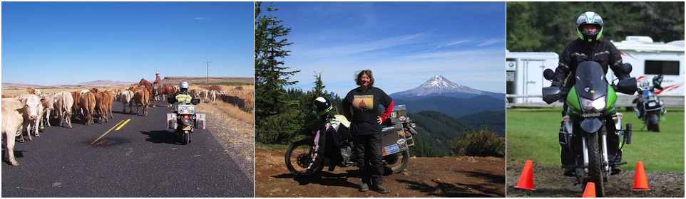
Here's some photos from some of these day trips.
And now this word from my husband:
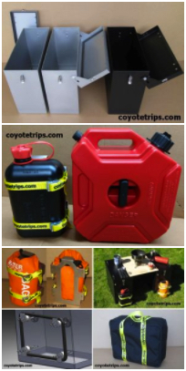

Adventure Motorcycle Luggage
& Accessories
www.coyotetrips.com
Tough, Durable Motorcycle Fuel Containers in two different
sizes,
Top Case Adapter Plates,
Facet Fuel Pump with & without holder (for Honda XRV750
Africa Twin, holder fits RD07 & RD07A only),
& Much More (check coyotetrips.com
frequently for latest offerings - they change!).
Designed or Curated by an experienced adventure motorcycle world
traveler
Based in Oregon. The designer & curator doesn't just sell
these items - they are what he uses himself (& me, his
wife). Nothing here hasn't been FULLY tested by the designer
himself.
You won't find these exact products anywhere else;
these are available only from Coyotetrips.
_______________________________________________
 Are you a woman? (however
you define that, I don't care). Have you traveled somewhere and
want to talk about it? Have a travel blog? Have an online album
of photos from your trip that you want to share? Have a tip for
travelers? You can post links to your blog at r/womenwhotravel,
an online discussion group on Reddit (a subreddit). Unlike other
women and travel subreddits and many other online communities,
this group DOES allow people to post links to their blogs,
YouTube channels, etc., so long as it's either focused on women
and travel or is by a woman who travels. Whether you are a
backpacker, a bicycle traveler, a budget traveler, a luxury
traveler, an adventure traveler, a cruiser, and whether its a
weekend getaway or some epic experience in another country, come
share your experiences at r/womenwhotravel.
And if you are an experienced traveler, join the group and help
answer questions from newbies. There's just one thing this group
doesn't allow: the question "Is such-and-such area safe."
Because that question is impossible to answer.
Are you a woman? (however
you define that, I don't care). Have you traveled somewhere and
want to talk about it? Have a travel blog? Have an online album
of photos from your trip that you want to share? Have a tip for
travelers? You can post links to your blog at r/womenwhotravel,
an online discussion group on Reddit (a subreddit). Unlike other
women and travel subreddits and many other online communities,
this group DOES allow people to post links to their blogs,
YouTube channels, etc., so long as it's either focused on women
and travel or is by a woman who travels. Whether you are a
backpacker, a bicycle traveler, a budget traveler, a luxury
traveler, an adventure traveler, a cruiser, and whether its a
weekend getaway or some epic experience in another country, come
share your experiences at r/womenwhotravel.
And if you are an experienced traveler, join the group and help
answer questions from newbies. There's just one thing this group
doesn't allow: the question "Is such-and-such area safe."
Because that question is impossible to answer.
 Quick Links
Index of resources for women travelers
(how to get started, health & safety considerations,
packing suggestions, transportation options, etc.
Advice for camping
with your dogs in the USA.
Advice for Traveling Around the
USA & Camping Along the Way.
Saving
Money with Park Passes in the USA
Advice for women motorcycle
riders and travelers
transire
benefaciendo: "to travel along while doing good."
advice for those wanting to make their travel more than
sight-seeing and shopping.
Where I've
been
A list of all of the states in the USA and all of the
countries I have lived in or traveled in, the farthest North
I've been by land, the nearest I've been to the equator,
various other stats. This includes all of the places I have
traveled to and through via motorcycle. If a place has a link,
then the link goes to my travelogue about the place
Some
of
my favorite photos from my travels. Very hard to
pick favorites.
Advice
for Hotels, Hostels & Campgrounds in Transitional &
Developing Countries: the Qualities of Great, Cheap
Accommodations


Disclaimer: Any activity incurs risk. The
author assumes no responsibility for the use of information
contained within this document.
This material is provided as is, with no expressed or implied
warranty.
Permission is granted to copy, present and/or distribute a limited
amount of material from my web site without charge
if the information is kept intact and is credited to Jayne
Cravens
Please contact me for permission
to reprint, present or distribute these materials (for
instance, in a class or book or online event for which you
intend to charge).
The art work and material on this site was created and
is copyrighted 1996-2026
by Jayne Cravens, all rights reserved
(unless noted otherwise, or the art comes from a link to
another web site).
The personal opinions expressed on this page are solely
those of Ms. Cravens, unless otherwise noted.
